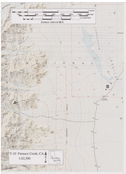
The following questions are based on Map T-10, the “Furnace Creek, California" quadrangle (scale 1:62,500; contour interval 80 feet; dotted lines represent 20-foot contours). This portion of the Furnace Creek quadrangle shows the Panamint Range and the western side of Death Valley in Death Valley National Park (36919'08"N, 116°53'25"W). Several large alluvial fans can be seen along the eastern front of the Panamint Range. The basin floor here is called the Death Valley "salt pan," because salts have accumulated here in great thicknesses. What is the local relief shown on the map?

Ans: 3738 ft
You might also like to view...
As a plate moves over the hot spot, the volcano moves off and dies, and a new volcano forms over the hot spot. This process generates:
a. volcano islands b. volcano acres c. independent volcanos d. hot-spot track

What will be an ideal response?
One of the most significant pull factors causing Jewish migration was
A) the internationalization of Jerusalem in 1946. B) the reunification of Jerusalem in 1967. C) the establishment of the State of Israel in 1948. D) the development of successful irrigation techniques in the desert. E) the beginning of the Cold War.
Which region is not threatened by desertification?
A) Africa B) Asia C) Australia D) North America E) All of the above are threatened by desertification.