If a map with these graphic scales is enlarged along with the scales (such as by using a photocopy machine)
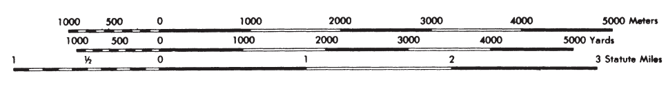
(a) Will the fractional scale of the map change? Why?
(b) Will the graphic scales (as shown) still be usable? Why?
(a) Yes. The size of the map relative to Earth has changed.
(b) Yes. They were enlarged the same amount as the map.
You might also like to view...
The poorest regions of China are generally:
A) in the northeast B) in the east C) in the south and west D) around cities on the eastern coast
Consider the 26 December, 2004 Indonesia earthquake where over 200,000 people died. If there had been an adequate tsunami warning system, how much time would there have been to get people to higher ground?
A. A few hours to a few days B. A few minutes to a few hours C. There was not enough time to get people to safety
Lunar regolith breccia contains crystalline rock fragments and glassy fragments formed by meteorite impacts
Indicate whether the statement is true or false
Which of the following terms describes organisms living on the surface of the sea floor moving along the bottom?
A) Benthonektos B) Epifauna C) Infauna D) Nektobenthos E) Planktofauna