Match the term with the most appropriate description.?
A. ?loggers cut intermediate-aged or mature trees singly or in small groups
B. ?an uncut or regrown forest that has not been seriously disturbed by human activities or natural disasters for at least 200 years
C. ?the most efficient and sometimes the most cost-effective way to harvest trees
D. ?harmful effects include topsoil erosion, sediment runoff into waterways, habitat loss, and loss of biodiversity
E. ?managed forest containing only one or two species of trees that are all the same age
A. ?selective harvesting
B. ?primary forest
C. ?clear-cutting
D. ?logging roads
E. ?commercial forest
You might also like to view...
Surface Weather Map
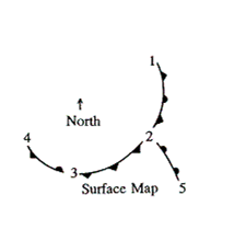 Refer to the above surface weather map.
Between which of the following points is an occluded front positioned?
Refer to the above surface weather map.
Between which of the following points is an occluded front positioned?
A. between 3 and 4 B. between 2 and 3 C. between 2 and 5 D. between 1 and 2
Determine the approximate amount of visible vertical displacement along each of the three fault scarps at their intersection with line AB (to determine the amount of visible displacement, measure the height [relief] of each fault scarp; it may be easiest to count the number of contour lines shown on each scarp to determine the elevation change).
The following questions are based on the “Mt. Dome, California,” quadrangle (Map T-24; enlarged to scale 1:48,000; contour interval 40 feet) and the stereogram of the same region (Figure 36-5; north is to the left side of the page). Three prominent fault scarps can be seen running north to south across the map, and will be referred to as the “western” fault, the “central” fault, and the “eastern” fault. These fault scarps are the result of normal faulting (41°49'39"N, 121°33'15"W). Western Fault: _______ feet Central Fault: _______ feet Eastern Fault: ________ feet
In a significant 2004 paper reviewing 69 studies on world human population and carrying capacity, the authors estimated that the sustainable carrying capacity of humans for Earth is about
A) 600 million. B) 2.5 billion. C) 7.7 billion. D) 20 billion.
Lagoons always occur:
a. on coastlines of emergence. b. in association with notches. c. in association with barrier islands. d. in association with marine terraces. e. next to spits.