What are the three primary feature types that GIS programs store as spatial data?
What will be an ideal response?
The three primary feature types that GIS programs store as spatial data are point, line, and polygon features.
Trades & Technology
You might also like to view...
In this illustration, which direction will the output member rotate?
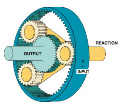
A) The same direction as the input
B) It will not rotate at all
C) The opposite direction to the input
D) Not enough information
Trades & Technology
An example of a fossil fuel is hydrogen.
Answer the following statement true (T) or false (F)
Trades & Technology
Horses were first domesticated between 4000 and 2000 B.C. on the steppes north of the Black Sea.
Answer the following statement true (T) or false (F)
Trades & Technology
A jump between segments of the FBD is represented by ________
A) ICON and IREF B) IREF and ICON C) OCON and ICON D) OREF and IREF
Trades & Technology