Fjord estuaries tend to be well mixed with high surface area
a. True
b. False
False
You might also like to view...
Why did the debris separate into two lobes at the far end of the slide?
The question is based on Figure 38-8, a digital elevation model showing the 2014 Oso, Washington, landslide along the North Fork Stillaguamish River, and color Map T-26b in the back of the Lab Manual, showing a portion of the “Mount Higgins, Washington” quadrangle (scale 1:24,000; contour interval 40 feet); this same topographic map is reproduced in black-and-white as Figure 38-14. What will be an ideal response?
Precipitation of 150–500 cm/year, outside the tropics:
From Table 29.1, the biome map, and the climate map, determine the terrestrial biome that best characterizes each of the following descriptions and write its name on the first line provided. On the second line, relate it to temperature and precipitation regimes and/or global pressure and wind belts outlined at the end of Section 1.
Which of the following is not an effect of popular culture?
A) Uniformity is substituted for differentiation. B) The individual is exposed to a broader range of available opportunities. C) It obliterates locally distinctive folk culture lifestyles. D) It reinforces tradition and resistance to change.
The site on the accompanying figure that would most likely form a rock that has a nonwelded texture with many fine particles is: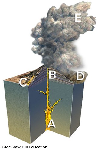
A. A B. B C. C D. D E. E