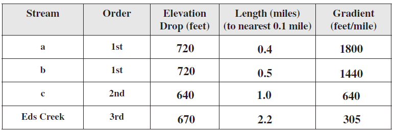
Using Map T-3, determine the gradients of the two first-order streams labeled “a” and “b” on the map above, the second-order stream labeled “c” on the map above, as well as Eds Creek after it has become a third-order stream. Determine stream length to the nearest 0.1 mile (take your measurements from Map T-3, not the small map above) using the graphic scale provided.
The following questions are based on Map T-3, the “Deer Peak, Montana” quadrangle (scale 1:24,000; contour interval 40 feet), and Figure 39-3, a stereogram of the same area showing the drainage basin of Eds Creek (46°54'26"N, 114°31'02"W).
You might also like to view...
The heaviest precipitation on Caribbean islands tends to be
A. on the southwest coast B. on the northeast-facing hills C. on the west coast D. on the capital city
The fastest seismic waves, which can travel through solids, liquids, and gases, are
____________________ waves. Fill in the blank(s) with the appropriate word(s).
Give the important components of both the single-cell and three-cell models of atmospheric circulation and analyze the strengths and weaknesses of each model
What will be an ideal response?
Condensation of water helps fuel tropical cyclones
Indicate whether the statement is true or false