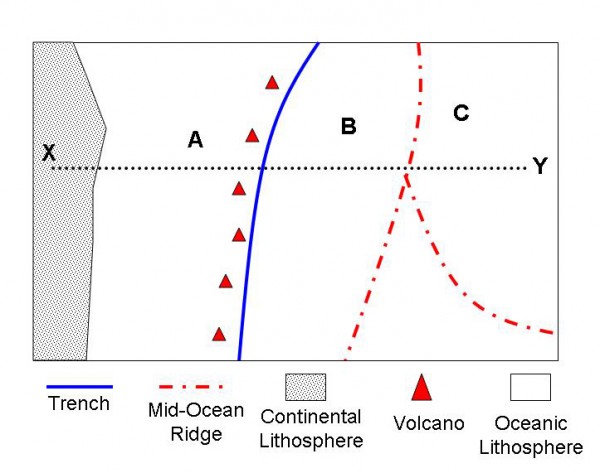
Analyze the plate boundary diagram shown. Assume north is toward the top of the diagram, west to the left, east to the right. Where would you find mountain ranges?

Analyze the plate boundary diagram shown. Assume north is toward the top of the diagram, west to the left, east to the right. Where would you find mountain ranges?
- Near A
- Near B
- Near X
- None of these locations
None of these locations
You might also like to view...
The line that separates Asian from Australian plant and animal species in Indonesia is called the
A. Mason-Dixon Line B. Free-throw line C. Wallace Line D. International Date Line
Which of the following soils is more likely to be found in an area of high rainfall and high temperatures?
A) histosols B) aridisols C) alfisols D) oxisols E) mollisols
This biome consists of large expanses of xerophytic grassland and scattered trees and shrubs adapted to drought, grazing by large herbivores, and fire
A) tropical rain forest B) desert C) tropical savanna D) Mediterranean shrubland
Meanders migrate or shift their location by
A. lateral erosion on the inside of meander bends. B. All of the choices are correct. C. sediment deposition on the inside of meander bends and lateral erosion on the outside. D. downcutting erosion.