What does LIDAR data tell us about shorelines?
A) how the size of waves is related to water temperature
B) how the size of waves is related to salinity of seawater
C) changes in elevation, including destruction of houses
D) how the color of sand affects the air temperature
E) None of these are correct.
C) changes in elevation, including destruction of houses
You might also like to view...
A clastic sedimentary rock layer located far away from the source area will contain __________.
a) Coarser and more angular grains b) Finer and more angular grains c) Finer and more rounded grains d) Coarser and more rounded grains e) Both rounded and angular grains
Violent conflicts are often in the news. Seldom do the environmental consequences of such conflicts make the news. As new weapons become more and more toxic, should the environmental consequences play a role in decision-making? Why or why not? The World Trade Center collapse had a devastating effect on the city of New York and its people. Does an event like this make a difference in your thinking? Why or why not?
What will be an ideal response?
Low pressure areas generally experience cloudy, unstable weather conditions
Indicate whether the statement is true or false
What type of glacier is shown on the gently sloping land near the coastline?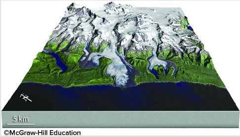
A. shoreline glacier B. continental ice sheet C. piedmont glacier D. tropical coast glacier