Where on the map is the center of high pressure influencing ocean currents with clockwise circulation?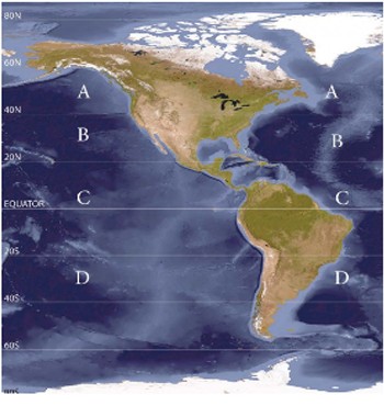
A. A
B. B
C. C
D. D
Answer: B
You might also like to view...
The concept of overlay in geographic information systems (GIS) refers to the
A) incorporation of multiple types of digital spatial data (maps) in answering research questions. B) constant, automatic updating of digital spatial data (maps) of the same type with newer data. C) use of digital spatial data (maps) to identify what lies deep beneath the Earth's surface. D) inclusion of a grid (such as latitude-longitude or universal Transverse Mercator) on a digital spatial dataset (map).
Describe what a drought is. What was the "Dust Bowl" of the United States and how was it created?
Which of the following best describe conditions in the mesosphere?
A) The mesosphere corresponds with the ozonosphere. B) The mesosphere is located between the troposphere and the stratosphere. C) Temperatures rapidly increase with altitude in the mesosphere. D) High altitude noctilucent clouds form in the mesosphere. E) The mesosphere is completely within the heterosphere.
When a TV weather forecaster gives a forecast for "widely scattered afternoon thunderstorms," these storms are probably associated with ________
A) a warm front generating thunderstorms along it B) the core of a midlatitude cyclone C) a cold front generating thunderstorms along it D) an unstable air mass, probably maritime tropical air with thunderstorms driven by thermals in an unstable air mass