GPS units
A) accurately allow determination of location anywhere on or near Earth's surface.
B) are a metric version of longitude and latitude.
C) are not available to the public; they are only available to the military and other government agencies.
D) have little practical use in physical geography.
E) are th of a Greenwich Precision Second.
A
You might also like to view...
The nation which initially dominated the Caribbean tourism trade was
A) Dominican Republic B) Bahamas C) Cuba D) Puerto Rico E) Barbados
Locate the high pressure cell centered over Idaho near Pocatello (shown in Figure 19-3 at about 45° N, 110° W). Based on the upper elevation wind patterns, in which direction would you expect this pressure cell to travel over the next few hours? Look carefully at the parallels and meridians, and be as specific as possible.
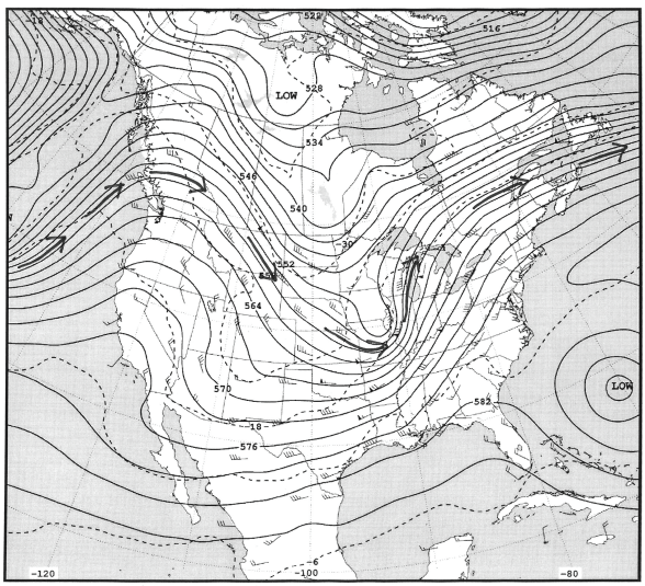
Figure 19-4: 500-Millibar Height Contours map for November 9, 2011.
What will be an ideal response?
Spodosols and permafrost, short summers:
From Table 29.1, the biome map, and the climate map, determine the terrestrial biome that best characterizes each of the following descriptions and write its name on the first line provided. On the second line, relate it to temperature and precipitation regimes and/or global pressure and wind belts outlined at the end of Section 1.
How might de forestation contribute to global warming?
A. Trees no longer produce oxygen. B. Trees no longer prevent soil erosion. C. Trees no longer remove carbon dioxide from the atmosphere. D. Burning of trees increases the heat output of Earth.