Seismic gaps represent
A. areas along an active fault where surface indications of the fault are absent.
B. "locked" sections along otherwise active faults.
C. periods of reduced or no seismic activity in the geologic record.
D. areas where there is little or no risk of earthquake activity.
Answer: B
You might also like to view...
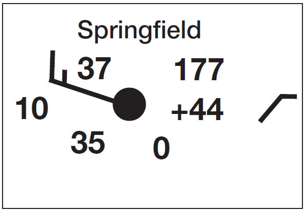
Describe the following weather conditions at 7:00 a.m. EST on November 9, 2011, in Springfield, Missouri (37° N, 93° W; an enlarged copy of the station model is shown here).
The following questions are based on the surface weather map shown below.

(a) Temperature: __________ °F
(b) Wind direction: ________________
(c) Pressure: __________ mb
(d) Pressure change over last 3 hours: __________ mb
(e) What explains this change in pressure?
(f) What explains the difference in temperature between Springfield and Nashville?
Developments in communication technology are linked to developments in weather forecasting because
A) most large-scale atmospheric motions are vertical, so accurate forecasts do not require knowledge of distant weather observations B) most large-scale atmospheric motions are vertical, so accurate forecasts require knowledge of distant weather observations C) most large-scale atmospheric motions are horizontal, so accurate forecasts do not require knowledge of distant weather observations D) most large-scale atmospheric motions are horizontal, so accurate forecasts require knowledge of distant weather observations
The temperature at which water boils depends mainly on
a. air temperature b. relative humidity c. air pressure d. air density e. the specific heat of air
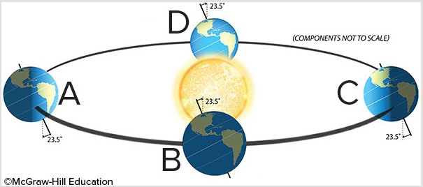
Which of the letters best represents summer for the Southern Hemisphere?
A. A B. B C. C D. D