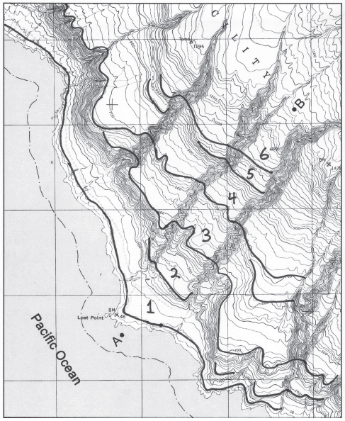
How many marine terraces are shown on the profile?
The following questions are based on Figure 49-8, a portion of the “San Clemente Island Central, California” quadrangle shown on the following page (scale 1:24,000; contour interval 25 feet; index contours drawn every fourth line; to view this map in color, go to the Lab Manual website or scan the QR code for this exercise), and the stereogram of San Clemente Island (Figure 49-7). The map and stereogram show a series of marine terraces on San Clemente Island in southern California (32°51"08"N, 118°29'58"W). The terraces have been incised by streams in several places.

Figure 49-8: USGS “San Clemente Island Central, California” quadrangle (scale 1:24,000; contour interval 25 feet; note that the index contours on this map have been drawn every fourth line;cN)
At least 6
You might also like to view...
List two differences between simple polygons and regions.
What will be an ideal response?
What is the Ogalala aquifer and how does agriculture benefit?
The boundary zone between adjacent biomes in which traits from both biomes may be found is called the
A) boundary layer. B) transitional matrix. C) edge effect. D) ecotone.
Judge the following sentence according to the criteria given below: It is advantageous for fishers to choose a population that feeds as close to the primary producing population as possible BECAUSE energy transfer between trophic levels is
inefficient. A) The assertion and the reason are both correct, and the reason is valid. B) The assertion and the reason are both correct, but the reason is invalid. C) The assertion is correct, but the reason is incorrect. D) The assertion is incorrect, but the reason is correct. E) Both the assertion and the reason are incorrect.