What is the highest elevation on the map segment? Location and name:
A sinuously curving, narrow ridge of coarse sand and gravel is called an esker. Eskers form along the channel of a meltwater stream that flows beneath a glacier, in an ice tunnel, or between ice walls beneath the glacier. As a glacier retreats, the steep-sided esker is left behind in a pattern roughly parallel to the path of the glacier.
What will be an ideal response?
1150' Hatt Hill
You might also like to view...
) Isolines
A) cannot be used to make precipitation maps. B) connect points of equal data value. C) were common on maps made before the nineteenth century, but are rarely used now. D) are needed to make sense of three-dimensional maps.
Why are rocks rich in magnesium and iron called mafic?
A) Mafic is the opposite of felsic. B) Ferric is the same as mafic, which means rich in magnesium and iron. C) Mafic comes from magnesium and ferric. D) Mafic is the Latin word that means rich is magnesium and iron.
In general, the most hazardous of all HAZMAT materials are those that demonstrate high levels of
A) ignitability. B) radioactivity. C) photoreactivity. D) corrosivity.
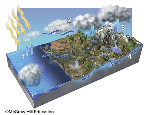
In which areas on the accompanying figure is condensation occurring?
A. 2 and 3 B. 2 and 4 C. 3 and 4 D. 1 and 3 E. 1 and 2