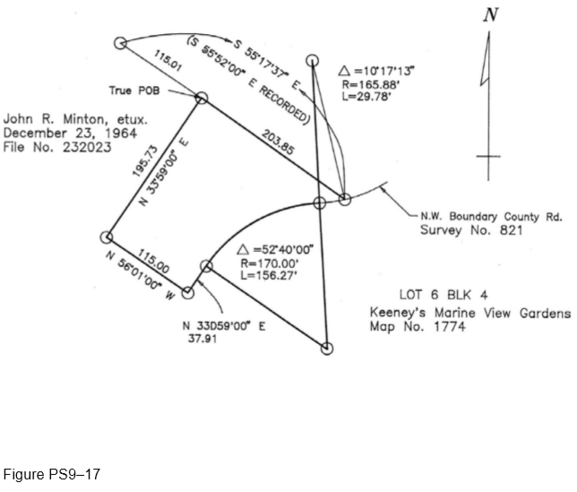
Legal Description: That portion of Lot 6 in Block 4 of Keeney’s Marine View Gardens, in the County of San Diego, State of California, according to Map thereof No. 1774, filed in the office of the County Recorder of San Diego County, December 31, 1923, lying within the following described boundary: Commencing at the most Northerly corner of that parcel of land delineated and designated as
“1.17 Acres (Net)” on Record of Survey Map No. 4270, filed in the Office of the County Recorder of San Diego County, April 18, 1957, being also the most Northerly corner of land described in deed to John R. Minton, et ux, recorded December 23, 1964, as File No. 232,023; thence along the Northeasterly line of said Minton’s land, South 55°17?37? East, (Record South 55°52?00? East) 115.01 feet to the TRUE POINT OF BEGINNING; thence continuing along said Northeasterly line South 55°17?37? East, 203.85 feet to the Northwesterly boundary of County Road Survey No. 821 (Highland Drive) as described in Parcel 2 in deed to the County of San Diego, recorded April 21, 1949, as Document No. 35,757 in Book 3179, Page 154 of Official Records; being a point on the arc of a 165.88 foot radius curve concave Northwesterly, a radial line of said curve bears South 13°38?13? East to said point; thence along said Northwesterly boundary as follows: Westerly along the arc of said curve through a central angle of 10°17?13? a distance of 29.78 feet to the beginning of a reverse 170.00 foot radius curve; Southwesterly along the arc of said curve through a central angle of 52°40?00? a distance of 156.27 feet to the point of tangency in the Southeasterly line of said Lot 6; and along said Southeasterly line tangent to said curve South 33°59?00? West, 37.91 feet to the most Southerly corner of said Minton’s land; thence along the Southwesterly line of said Minton’s land North 56°01?00? West, 115.00 feet to a line which bears South 33°59?00? West from the True Point of Beginning; thence North 33°59?00? East, 195.73 feet to the TRUE POINT OF BEGINNING. ALSO that portion of Lot 6 adjoining the above described land as shown on said Record of Survey Map No. 4270 that lies Westerly of the Southeasterly prolongation of the Northeasterly line of the above described land.
What will be an ideal response?
See Figure PS9–17.
You might also like to view...
The Occupational Safety and Health Administration is an agency of the United States Department of ____.
a. Health b. Commerce c. Education d. Labor
Water molecules have polarity primarily because each contains two H atoms and only one O atom
Indicate whether the statement is true or false
When tuning across the resonant frequency of a series RLC band-pass filter, which of the following is true?
A) Current flow through the load is minimum. B) The impedance of the filter should be minimum at resonance. C) The impedance of the filter should be maximum at resonance. D) The output voltage across the load is minimum.
Find the slope of the line that passes thru the points (2,1) and (8,5).
What will be an ideal response?