A ________ uses standardized symbols and patterns to represent rock types and geologic structures.
A. geologic column
B. geologic map
C. Google Maps
D. topographic map
E. correlation map
Answer: B
You might also like to view...
In glacial deposits, a long sinuous ridge of gravel and other sediment deposited by meltwater from a retreating glacier or ice sheet is called:
a. Kame b. Esker c. Kettle hole d. Hummocky ridge
Mercury toxicity has been directly linked with which one of the following health problems in humans?
A. respiratory problems B. hepatitis C. neurological disorders and paralysis D. cancer E. digestive disorders
The light blue area just off the Australian coast, as shown here, is called the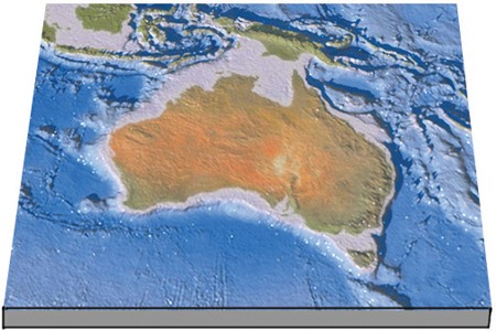
A. seashore. B. continental platform. C. continental shelf. D. abyssal plain.
A weather map symbol of a line containing only semicircles that are all located on one side of the line depicts a(n) ____
a. warm front b. occluded front c. stationary front d. cold front e. squall front