What is the “local relief” of this landscape (the difference in elevation between the highest and lowest locations)?
The question is based on this contour line map with elevations shown in feet.
• North is to the top of the map.
• Streams are shown with dashed lines.
• A graphic scale for measuring horizontal distances is shown below the map.
• Estimate elevations between contour lines to the nearest half-contour interval; assume that the top of a
hill is one-half-contour interval higher than the highest contour line shown.
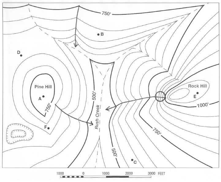
What will be an ideal response?
700 feet
You might also like to view...
A cannon recoils from firing a cannonball. The speed of the cannon's recoil is small because the
A) force against the cannon is smaller than against the ball. B) momentum is mainly concentrated in the ball. C) cannon has more mass than the ball. D) momentum of the cannon is smaller.
The process by which the population of urban settlements grows is known as migration
Indicate whether the statement is true or false.
Fair Trade ________ the percentage of the retail price that ________ in ________ countries receive
A) improves, distributors, developed B) protects, distributors, developed C) reduces, producers, developing D) reduces, importers, developing E) improves, producers, developing
The World Wildlife Federation claims the world surpassed its sustainable level around
A) 1960. B) 1970. C) 1980. D) 1990. E) 2000.