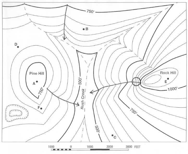
What is the horizontal distance from C to B?
The question is based on this contour line map with elevations shown in feet.
• North is to the top of the map.
• Streams are shown with dashed lines.
• A graphic scale for measuring horizontal distances is shown below the map.
• Estimate elevations between contour lines to the nearest half-contour interval; assume that the top of a
hill is one-half-contour interval higher than the highest contour line shown.

What will be an ideal response?
5700 feet
You might also like to view...
Please explain why you selected the houses you did in Q1 and Q2. Please include what types of hazardous phenomena (e.g., liquefaction, tsunami, landslide, etc.)
you would expect at the other two houses you didn't select in Q1 and Q2 that would make it an earthquake hazard and WHY. What will be an ideal response?
This type of fog often forms in California's Sacramento Valley on a clear winter night with light winds
A) evaporation fog. B) frontal fog. C) radiation fog. D) advection fog. E) upslope fog.
How did Wegener account for evidence of glaciers in portions of South America, Africa, and India when areas in North America, Europe, and Asia supported lush tropical swamps?
What will be an ideal response?
Which of the following is NOT true about shield volcanoes in the landscape?
A. They are large mountains with steep slopes. B. They can be large or small. C. They can construct some of the world's largest volcanoes. D. All of these are true.