On the topographic map in Figure 43-3, determine the extent of inundation for the 20-year flood along Cache Creek that you calculated in problem 8:
(a) Convert your flood level height in problem 8 from meters to feet (the measurement units used on the map):
Water height of 20-year flood: _______ feet
(b) Using a blue pencil, shade in the extent of the 20-flood on the map. Note that elevation of the stream gage is 1534 feet and that dashed lines are 20-foot contours.
(a) 13.5
(b) 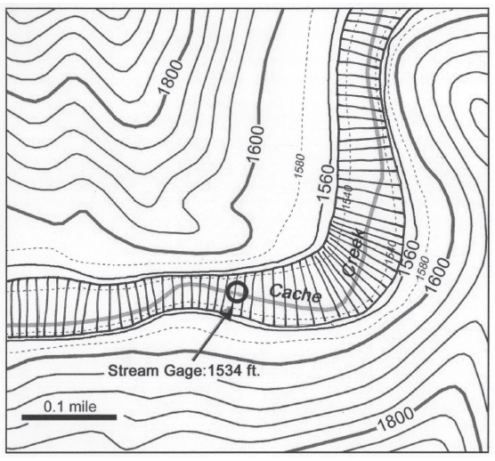
Figure 43-3: Portion of USGS “Hough Springs, California” quadrangle (enlarged to approximately scale 1:8000; contour interval 40 feet; dashed lines are 20-foot contours; Nc).
You might also like to view...
The cells involved in blood clotting are
A) red blood cells. B) white blood cells. C) platelets. D) hemoglobin.
Local ________ is in opposition to the force of globalization
Fill in the blank(s) with the appropriate word(s).
Environmental problems associated with wind power are:
A. transportation required of electricity over long distances is required. B. only produce electricity when the wind blows. C. vibrations causing earthquakes. D. hazardous to birds, and some people consider them to be a form of visual pollution.
The purchase of a service by a firm rather than producing it in-house is called ________
Fill in the blank(s) with correct word