If a researcher wanted to identify and map healthy vegetation using remote sensing, she would most likely use. Data that detects what type of energy?
A) Microwave
B) Near-infrared
C) Sonar
D) Thermal infrared
B) Near-infrared
You might also like to view...
The figure below shows a layer of relatively fast-moving air overlying a layer of more slowly moving air. Where do eddies and turbulent air motions likely form?
?
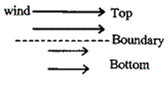
A. in the bottom layer B. in the top layer C. in the boundary between the two layers
Which of the following most likely indicates that the sea level has fallen relative to the land?
A) Offshore sand bars that have become coastal dunes B) The presence of coral reefs on land C) Wave-cut notches and platforms that are above sea level D) Marine terraces E) All of these are correct.
Clearing forests can
A. alter rainfall patterns. B. alter rainfall patterns and increase runoff. C. enhance transpiration. D. increase runoff. E. alter rainfall patterns and enhance transpiration.
Latitude is a measurement that uses the prime meridian (Greenwich, England) as a reference point to help determine the exact location of a specific point on Earth
Indicate whether the statement is true or false