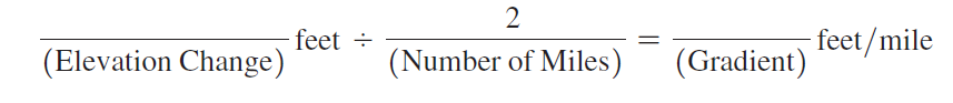
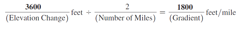
Using Map T-2, the “Umnak, Alaska,” topographic map (scale 1:250,000; contour interval 200 feet), calculate the gradient of Mount Vsevidof (53°07'35"N, 168°41'16"W) along line CD, from the 1000' contour (near Point C) toward the summit. On the edge of a piece of paper measure out a distance of 2 miles using the graphic map scale, and then determine the elevation change over that distance.
In this problem, you will compute the gradients of Mauna Loa in Hawai‘i, Mount Vsevidof in Alaska, and SP Mountain in Arizona. (You may also determine the elevation changes and distances needed to calculate these gradients by using Google Earth™.) The recommended starting point and distance to measure are given for all three volcanoes.
You might also like to view...
In downtown Philadelphia, water in storm drains most likely came from
A) sinks. B) toilets. C) lawns and streets. D) bathroom showers.
Divergence aloft suppresses thunderstorm activity
Indicate whether the statement is true or false
If you traveled to another earthlike planet with an ocean, how could you determine if tectonic plates and plate tectonic movement existed?
a) Look for mountain ranges, oceanic ridges, oceanic trenches, and volcanoes b) From satellite imaging, observe a jigsaw fit of the continental edges c) Check seismic readings for earthquake activity d) All of the above
Which environmental law created a giant fund to remediate abandoned toxic waste sites?
A. Alaska National Interest Lands Act of 1980 B. National Forest Management Act of 1976 C. Comprehensive Environmental Response, Compensation, and Liability Act of 1980 (CERCLA) D. Resource Conservation and Recovery Act of 1976 E. Toxic Substances Control Act of 1976