A geographic information system allows a link between data and ________
A) scientific theory
B) a map
C) a computer
D) a color
E) orthophoto mapping
Answer: B
You might also like to view...
The mass number of an element is
A. the sum of the isotopes. B. the sum of the electrons and the neutrons. C. the sum of the protons and the neutrons. D. the number of protons. E. the sum of the electrons and the protons.
KM
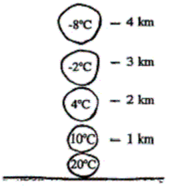 If the environmental lapse rate in the figure above is 8°C/km, at what altitude will the air parcel become warmer than its environment?
A. 1 km B. 2 km C. 3 km D. 4 km
How did the study of bathymetry progress with new technologies? Include important developments and events in history that impacted bathymetry
Which statement is true about the lithosphere?
A) The lithosphere is thickest at the mid-ocean ridges because of the quantity of magma that flows up to the surface. B) The lithosphere gets thicker as distance from the ridge increases, because it cools and the boundary between the lithosphere and asthenosphere occurs at greater depth. C) The lithosphere maintains its thickness as distance from the ridge increases, because the boundary between the lithosphere and asthenosphere remains at a constant temperature and depth. D) The lithosphere gets thinner as distance from the ridge increases, because decompression melting occurs with decreased pressure.