If gradient were the only factor controlling the erosive power of these streams, what should happen to the position of the mesa edge with time?
The following questions are based on Figure 39-4, a section of USGS “Dane Canyon, Arizona” quadrangle below, showing the southern edge of the Mogollon Mesa (34°24'33"N, 111°10'52"W), formed by a nearly flat-lying layer of resistant rock (you can view this map in color by going to the Lab Manual website or by scanning the QR code for this exercise).
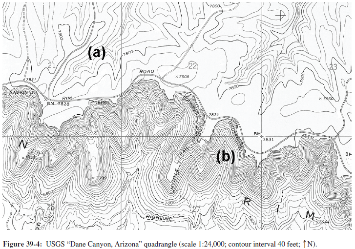
The edge of the mesa should migrate to the north as it erodes back.
You might also like to view...
Which circle has more than half of the world's population? A circle that fits a triangle described by
A) Pakistan-Japan-Indonesia B) England-Eastern Russia-Egypt C) Alaska -Eastern Canada-Venezuela D) Hawaii-Brazil-Argentina E) Spain-Iran-South Africa
Which of the following is the least biodegradable?
A) Paper bag from a grocery store B) Leaves and branches piled up on a hillside C) Glass beer bottle D) Polyethylene wrapper that was used to package Campbell's soup
Who reaps the most economic benefits associated with the Green Revolution?
A) dictatorships B) farmers in mid-latitude countries (Australia, France, Germany, for example) C) international shipping companies D) large-scale wealthy farmers in the developing world E) small-scale farmers (of any wealth) in the developed world
________ ________ are companies that operate factories or service centers in countries other than the country of origin
Fill in the blank(s) with correct word