If you were flying across the Western United States and saw the landscape was divided by roads and fields that ran precisely east-west and north-south in regular squares and rectangles you might logically assume that this part of the country had been
surveyed using what system? A) Metes and bounds
B) Township and range
C) Long Lot
D) Lot and block
B
You might also like to view...
Compare and contrast the three major types of plate tectonic boundaries. Discuss the tectonic features along each of
these boundaries. Provide specific examples of each type of boundary. What will be an ideal response?
A concentrated solar thermal power facility concentrates solar energy by ________
A) using photovoltaic panels to produce electricity B) collecting light in a series of fiber optic cables directed to underground steam rooms C) heating water in pipes that run along rows of mirrors D) using a large array of reflectors to direct sunlight to a collector
Dune migration threatens human structures and may adversely affect human health
Indicate whether the statement is true or false
Which location on this figure from the Investigation is located on the abyssal plain?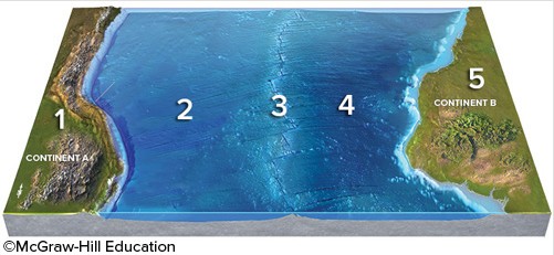
A. 1 B. 2 C. 3 D. 4 E. 5