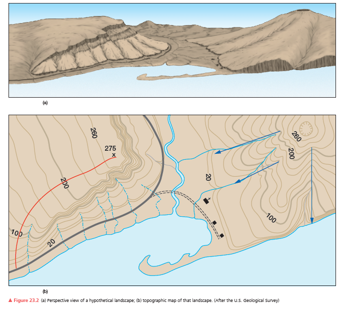
Use the hypothetical landscape and topographic map in Figure 23.2. What is the contour interval? How can you tell?

What will be an ideal response?
20 ft is the contour interval for the topographic map of the hypothetical landscape. From the numbers on the lines (5 intervals between every 100 feet)
You might also like to view...
Trade Winds are caused by
A) Steady winds from sub-tropical low-pressure zones to equatorial high-pressure zones. B) Steady winds from sub-tropical high-pressure zones to equatorial low-pressure zones. C) Steady winds from equatorial low-pressure zones to sub-tropical high-pressure zones. D) Steady winds from equatorial high-pressure zones to sub-tropical low-pressure zones.
Which of the following has the highest density?
A. 1037 kg/m3 B. sigma-t = 13.6 C. 1011.7 kg/m3 D. sigma-t = 26.4 E. 1.039 g/cm3
Which of the following igneous rocks is NOT characteristic of mid-ocean ridges?
A. andesite and granodiorite B. gabbro that solidified in a magma chamber C. pillow basalt D. finely crystalline rocks that formed in dikes
A matter of great concern is that many of the places where existing climates are predicted to disappear also happen to regions currently with great ________
A) snow cover B) biological diversity C) vertical zonation D) rises in sea level E) numbers of fossils