Which of the following are typically shown on a weather map?
A. locations of weather systems and fronts.
B. locations of weather systems, cyclones, anticyclones, and air masses.
C. locations of air masses and fronts.
D. locations of weather systems, air masses, fronts, and greenhouse gas concentrations.
Answer: A
You might also like to view...
Although oceanographers may specialize in one particular area of study, the nature of the science is interdisciplinary,
meaning that marine scientists must have a general knowledge of all areas of oceanography in order to study the system as a whole. a. True b. False
A small residential pond in the middle of an urban housing development is most likely
A) a natural pond that happened to be in the region where the homes were built. B) part of a storm-water management system, to reduce erosion from runoff. C) constructed specifically as a source of water for people to use to irrigate their lawns. D) part of the sewage treatment facility that serves the homes in this region.
In the diagram below, which layer(s) correspond to the mantle?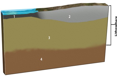
A. 3 and 4 B. 3 C. 4 D. 1 and 2
Which of the following concerning the Ogallala is FALSE?
A) It is the largest water supply in Mexico. B) Most of it is literally being "mined." C) It is estimated that many irrigated acres will soon have to return to dryland farming. D) It contains as much water as one of the Great Lakes. E) The aquifer is most abundant under the Sandhills.