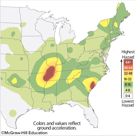
The image indicates that
A. two major zones exist for earthquake risk in the eastern United States.
B. Florida has the highest risk for earthquakes along the east coast.
C. the eastern United States is under no risk for earthquakes.
D. the risk for earthquakes in extreme southeast Missouri is very low.
Answer: A
You might also like to view...
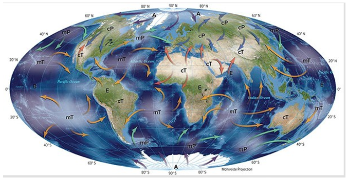
Which of the following air masses pictured here is dry, unstable, and hot?

A) mP
B) mT
C) cP
D) cT
Which of the following does not accurately describe Earth's distance from the Sun?
A) The Earth-Sun distance averages 150 million kilometers (93 million miles). B) It takes light an average of 8 minutes and 20 seconds to travel from the Sun to Earth. C) Earth is closer to the Sun in January (perihelion) and farther away in July (aphelion). D) The Earth's orbit around the sun is presently circular and, therefore the Earth is always equidistant from the sun throughout the year.
Convergent boundaries, due to their geometry, are the sites of the largest earthquakes on Earth.
Answer the following statement true (T) or false (F)
Deciduous forests
A. Have trees that bear seeds in cones B. Are not useful commercially C. Are adapted to extremely cold climates D. Have trees that shed their leaves seasonally