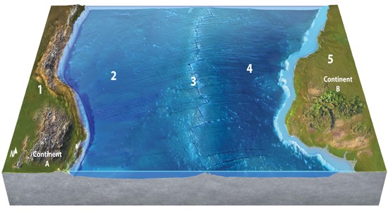
The safest place for humans to live, away from volcanic activity and earthquakes, is
A. 1.
B. 2.
C. 3.
D. 4.
E. 5.
Answer: E
You might also like to view...
Who owns the dataset?
Earthquakes are one of the biggest natural disaster risks in some parts of the world. In this exercise you will add the USA Earthquake Risk layer to your map and assess the earthquake risk in several areas. Find the USA Earthquake Risk layer by selecting “Add” then “Browse Living Atlas Layers.” Next select “Landscape” then “Ecology” and “USA Earthquake Risk.” Add the layer to your map by clicking “Add layer to map (as layer).” In the Content window on the left side of the screen, click on the ellipses below the layer name and then select “Show item details.” A new screen should appear in your web browser that describes the dataset in the Description and Dataset Summary sections. If more information about the dataset is desired, users can click on “Link to source metadata” toward the bottom of the page. Answer the question about the dataset.
Despite their instability, over 70 barrier islands off the United States have been commercially developed
Indicate whether the statement is true or false
The freezing point of seawater is lower than that of freshwater due to the presence of dissolved salts
Indicate whether the statement is true or false
Why is beach sediment typically quartz-rich sand?
A. quartz is the only mineral that can be sand-sized B. quartz is resistant to chemical weathering C. other minerals are not deposited on beaches D. none of the preceding