Use the map below to answer this question.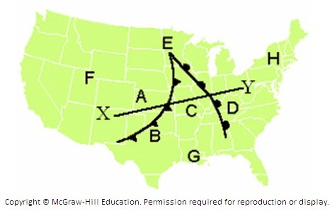 The illustrations below represent a slice through the cold and warm fronts along line X-Y on the map. Which of the images below best represents conditions along the line X-Y?
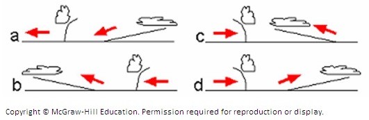
A. Diagram a
B. Diagram b
C. Diagram c
D. Diagram d
Answer: D
You might also like to view...
Passive solar heating systems involve
A. green roofs. B. pumping a heat-absorbing fluid through collectors on the roof. C. wind turbines with solar panels attached. D. foil sheets under the floor. E. adobe walls and windows that face the sun and store the collected solar energy.
For a family from St. Louis, Missouri considering a drive to Las Vegas, Nevada, the Ozark entertainment center of Branson, Missouri presents an intervening opportunity
Indicate whether this statement is true or false.
The territory of Antarctica has been claimed by
A) the core countries. B) countries of the periphery. C) no country. D) the United Nations. E) a handful of countries from both the North and the South.
Which nation, twice the size of Texas, has a population of only 3.1 million people?
A) Kazakhstan B) Mongolia C) Afghanistan D) Uzbekistan E) Kyrgyzstan