Why is the study of sediments so important? What kind of information can be discovered by studying
sediments? How have tools and equipment evolved to expand the study of sediments? What will be an ideal response?
ANS:Answer
should include:
? Sediments are able to provide a history of the world to some extents. They can provide
information on past ocean and atmospheric conditions. They can be dated to age
different layers. Sediments can be analyzed to determine the composition of the seafloor
and plate tectonic activities. The fossils inside sediments can even show the evolution of
life-forms in the ocean.
? The sampling of sediments began as a rudimentary operation. The HMS Challenger
expedition used weighted, wax-tipped poles to collect sediment samples. When these
poles hit the ocean floor, the sediment would stick to the wax.
? Sampling methods progressed from using wax-tipped poles. Clamshell samplers are able
to collect sediments from shallow water. This piece of equipment is an open claw that
has a mechanism that snaps the claw shut once it hits the bottom. The sediment is then
trapped inside and hoisted back up onto a ship for analysis. Due to the nature of this
device, only the surface layer of sediment is collected.
? The piston corer is the machinery that revolutionized sediment sampling. This machine
is able to take deep samples of sediments from the ocean floor. In some cases, 25 meter
deep samples have been acquired. The results from these core samples facilitated two
new forms of science: stratigraphy and paleoceanography. Currently, there are even
libraries where these cores are stored so scientists can analyze them.
? The use of cameras was important to studying sediments before some of the sampling
techniques were perfected. Early cameras were lowered on a cable and then trip wired to
turn on once they reached the bottom. This allowed scientists to see the sediment, even if
they could not collect it. Cameras eventually were towed behind ships and attached to
deep submersibles to generate views of even deeper depths.
? Seismic profiling is being used to show thickness and layers of sediment. In some cases,
underwater mount ranges can be seen beneath a thick layer of sediment.
You might also like to view...
To spear a fish with a regular spear, compensate for refraction and throw your spear
A. directly at the sighted fish. B. above the sighted fish. C. below the sighted fish. D. none of the above
What is the maximum width (or length) of the largest dune?
The following questions are based on the portion of the “Kane Spring NW, California” quadrangle (scale 1:24,000; contour interval 10 feet) shown in Figure 46-6. These isolated dunes in the desert near the Salton Sea (33°11'02"N, 115°52'20"W) are moving over a surface that is only thinly covered with sand. To view this map in color, go to the Lab Manual website or scan the QR code for this exercise. What will be an ideal response?
Carbon is a major component of ____.
A. water B. the oceans C. organic compounds D. the atmosphere E. hydrologic cycle
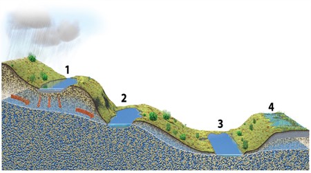
Of these four lakes, which ones are above the water table?
A. 1 and 2 B. 3 and 4 C. 1 and 4 D. 2 and 3 E. None of these.