The following questions are based on Maps T-25a and T-25b, Figure 37-3, a detailed topographic map of the San Andreas Fault, Figure 37-5, a stereogram of the San Andreas Fault in the Carrizo Plain National Monument, and Figure 37-6, a portion of the “McKittrick Summit, California,” quadrangle reproduced on the next page. The stereogram shows the area in the southern half of the topographic map.
1. One offset stream (known as “Wallace Creek”) has been labeled for you on the map 135°16'16"N, 119°49'38"W). On the map on the following page, use an arrow labeled “1” to identify another stream that has been offset by displacement along the fault. The contour pattern of dry gullies may also provide you with clues.
Note: Several streams have had their courses deflected to the left rather than to the right. This can happen, for example, when a small shutter ridge is carried along one side of the fault, blocking a stream’s course and causing it to flow along the trace of the fault (in this case, to the southeast) until it finds an outlet.
2. On the map on the following page, use an arrow labeled “2” to identify a small linear ridge running parallel to the trace of the fault. (Hint: Look for tiny closed contour lines along the fault trace.) The stereogram, detailed topographic map, and aerial imagery may also be helpful in identifying ridges.
3. On the map on the following page, use an arrow labeled “3” to identify a sag or sag pond. The stereogram may be helpful in identifying sags and dry sag ponds.
4. What stream features, seen in the stereogram, aerial imagery, and detailed topographic map but not the Figure 37-6 map, indicate the position of the fault? (Hint: Look for small stream gullies that flow down toward the fault.)
5. Based on the topographic clues you have identified above, as well as the aerial imagery in Map T-25b and stereogram of the same region, use a colored pencil to sketch in a line showing the position of the San Andreas Fault across the map on the following page.
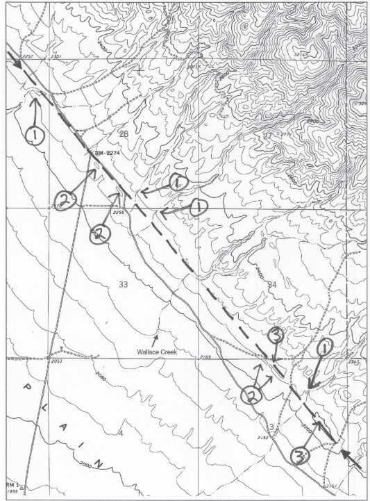
Figure 37-6: USGS “McKittrick Summit, California” quadrangle (scale 1:24,000; contour interval 40 feet; cN).
Many small gullies on the fault scarp stop abruptly at the fault.
You might also like to view...
In the diagram below, regolith forms in which area?
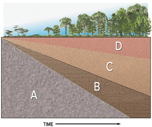
A) A
B) B
C) C
D) D
Which of the following is not true of the area of the Polar High?
A) In the polar regions, the intense cold caused by low insolation creates dense air and high pressure B) In the polar high-pressure zones, the air is so cold, it contains very little moisture. C) In polar high zones, there is very little moisture, with limited convection and precipitation. D) There is a polar high zone in both the Northern and Southern Hemispheres E) The differential temperature between the rising air as a result of the warm anti-trade winds and the jet stream leads to turbulent winds and rain
Plutons form within the peaky structure of a volcano. Indicate whether the statement is true or false
English is part of which language branch?
A) Germanic B) North Germanic C) West Germanic D) Indo-European E) Austronesian