Other than the levees, does there appear to be any land more than 25 feet higher than the river between Alsatia (west of the Mississippi River along Highway 65) and the Mississippi River itself?
The question is based on Map T-5, a portion of the “Jackson, Mississippi-Louisiana” topographic map (scale 1:250,000; contour interval 50 feet; dashed lines are supplementary contours at 25-foot intervals). A color satellite image of this same region is shown in Figure 40-5 (scan the QR code for this exercise or go to the Lab Manual website and Exercise 40). For reference, the dashed contour line on “Paw Paw Island” in the southern part of the map shows an elevation of 75 feet.
What will be an ideal response?
No
You might also like to view...
American beavers, Castor canadensis, are widespread in North America. Those American beavers living around lakes in northern Minnesota and that can potentially interbreed
A) are probably another beaver species. B) represent one population of American beavers. C) likely look much different than beavers in Wisconsin. D) belong to the same family but not the same genus as other beavers.
One drainage basin is separated from a neighboring drainage basin by a ________
A) divide B) slope C) rill D) zone of deposition
The site on the accompanying figure that would most likely form a rock that has a welded texture is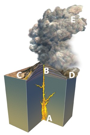
A. A. B. B. C. C. D. D. E. E.
Most volcanoes have a(n) _______________ stream pattern
Fill in the blank(s) with correct word