The adjusting of geospatial datasets in real time to make changes to maps and other visual models is called
A) global positioning. B) geographic synchronization.
C) geovisualization. D) remote sensing.
C
Environmental & Atmospheric Sciences
You might also like to view...
In science, especially physics, an educated guess is called a
A. fact. B. theory. C. both a fact and a theory. D. none of the above
Environmental & Atmospheric Sciences
For the following acid-base reaction, identify what is formed in the space marked. HF + KOH ? ???? + H2O
A. H3OF B. KF C. KOH2 D. KOH2F E. none of the above
Environmental & Atmospheric Sciences
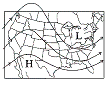
Surface Map

A. cP B. cT C. mP D. mT
Environmental & Atmospheric Sciences
When an iron ring is heated, the hole becomes
A) smaller. B) larger. C) neither smaller nor larger.
Environmental & Atmospheric Sciences