Describe the general topography of the region between Clinch Mountain and Powell Mountain.
The following questions are based on Map T-6, the “Johnson City, Tennessee-Virginia-Kentucky- North Carolina” topographic map (scale 1:250,000; contour interval 100 feet). This map shows a portion of the Appalachian Mountains at the Tennessee, Kentucky, and Virginia border 136°39'30"N, 83°01'05"W). Figure 41-4 is a satellite image of this same region (to view this image, scan the QR code for this exercise or go to the Hess Laboratory Manual website and Exercise 41).
What will be an ideal response?
Eroded parallel valleys.
You might also like to view...
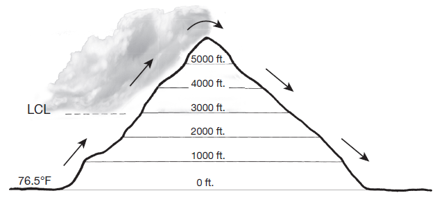
On the lee side of the mountain, is the relative humidity of the parcel increasing or decreasing as it descends from 6000 feet to sea level? Why?
Assume that a parcel of air is forced to rise up and over a 6000-foot-high mountain (as shown). The initial temperature of the parcel at sea level is 76.5°F, and the lifting condensation level (LCL) of the parcel is 3000 feet. The DAR is 5.5°F>1000 feet and the SAR is 3.3°F>1000 feet. Assume that condensation begins at 100% relative humidity and that no evaporation takes place as the parcel descends. Indicate calculated temperatures to 1 decimal place.

What will be an ideal response?
Which of the following rock types requires dissolved gas in the magma?
A. gabbro B. diorite C. andesite D. pumice E. granite
The concept of sustainable development includes
A) the needs of future generations. B) growth in profits from international trade. C) the importance of developing the arts. D) the fastest ways to economic prosperity.
What are three adaptation steps that could be taken to anticipate inevitable changes in climate?
What will be an ideal response?