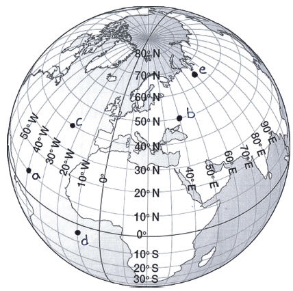
On the diagram shown, plot the following coordinates with a dot. Then label each dot with its corresponding letter.
(a) 10° N, 40° W
(b) 50° N, 40° E
(c) 40° N, 25° W
(d) 5° S, 10° W
(e) 65° N, 70° E
You might also like to view...
The depth at which the cellular respiration rate equals the photosynthetic rate is referred to as the ________ for photosynthesis
A) carbonate depth B) epipelagic depth C) euphotic zone D) compensation depth E) productive zone
Which phytoplankton flourished in the Miocene, probably because of increased volcanism?
a. coccolithophores b. diatoms c. dinoflagellates d. foraminifera e. radiolarians
The following table shows three fields of a land use layer with 10 polygons. The following questions relate to a series of queries in continuous sequence.LucodeCosthaHectare200200004.574001000010.50300100003.31300100000.44300100000.10300100000.72200150001.10300100000.19200150000.75200150000.78Next, you set up the expression, lucode = 200 OR hectare > 10, and click "Create a new selection." How many records are selected?
What will be an ideal response?
Which activity is least likely to be involved with the sustainable management of freshwater fisheries?
A. supporting populations of commercial and sport fish species B. facilitating the introduction of commercially important nonnative species C. preventing overfishing D. building and stocking reservoirs and farm ponds E. controlling predators and parasites