A map capable of showing true directions as straight lines running through a central point is called a(n) ____
a. Mercator map
b. equal-area map
c. planar map
d. focal map
e. azimuthal map
e
You might also like to view...
In the soil profile below, iron is present in both the top and bottom layer, as labeled, but why is only the second layer a reddish color?
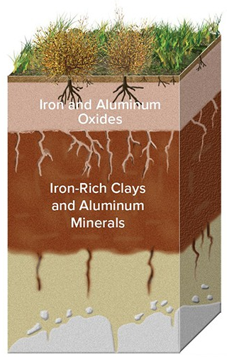
A) The iron oxide was leached from the top layer in what was most likely a wet environment.
B) The iron oxide was leached from the top layer in what was most likely an arid environment.
C) When exposed to air, the iron oxide loses its reddish tint in what was most likely a wet environment.
D) When exposed to air, the iron oxide loses its reddish tint in what was most likely an arid environment.
How are natural levees formed?
A) Bedload rises up over river banks during high floods. B) Suspended load is deposited when the river covers the floodplain. C) Minerals precipitate at the sides of rivers when the water is at bankfull level. D) Cementing action occurs at the sides of streams as a result of the high velocity of the water.
The line separating the dark half of Earth from the lighted half is called the ________
Fill in the blank(s) with correct word
What happens to the land surface when large ice sheets melt away?
A. The land flexes upward due to isostatic rebound. B. The land surface remains unchanged but seems lower because of the loss of ice. C. The land rises because the rocks are warmer without the ice. D. It subsides because there is less ice on top.