The highest peak in the lower 48 states is located where?
A) The Sierra Nevadas
B) The Rocky Mountains
C) The Cascade Range
D) The Tehachapi Mountains
A
You might also like to view...
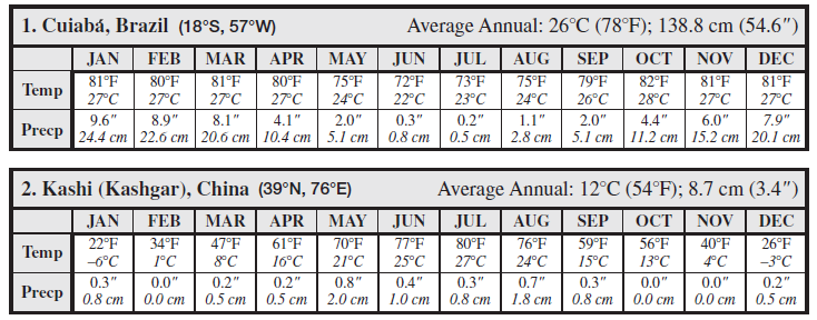
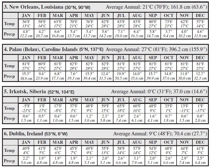
For each of the following six locations, complete the climograph using the average monthly temperature (“Temp”) given in degrees Celsius and Fahrenheit, and the average monthly precipitation (“Precp”) given in centimeters and inches. The average annual temperature and precipitation are provided for you. After completing the climographs, answer the questions at the end of Part I. You may plot data on the climographs using either S.I. or English (note that the English unit and S.I. unit scales on the climographs are not exactly equivalent). It may be helpful to locate each of these stations on a map (the latitude and longitude of each location is provided). No “H” climates are given.


A central circle on a station model that is 75 percent black and 25 percent white tells you
A) there is a 75 percent chance of rain. B) the cloud cover ranges over 70 to 80 percent of the sky. C) the northwest quadrant of the sky is clear, while the remainder of the sky is cloudy. D) it is currently raining in moderate amounts.
Sediment scraped off the subducting plate builds up in a(n) ________
A) horst B) delta C) accretionary wedge D) basin
The _______________ is the imaginary circle around Earth halfway between the two poles
Fill in the blank(s) with correct word