Is unaltered parent material (the R horizon) visible in this soil profile?
The following questions are based on Figure 27-3, the photograph of a soil profile. You may view this image in color by going to the Lab Manual website at www.MasteringGeography .com, or by scanning the QR code for this exercise. The depth scale is in inches.
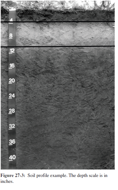
What will be an ideal response?
No
You might also like to view...
Which is NOT TRUE regarding capitalism?
A) A division of wealth often exists between cities and the countryside. B) Capital seeks out the highest rate of profit. C) Capitalism can cause uneven spatial development (wealth of New York versus situation of Detroit). D) Prior to colonialism, Europe was the wealthiest and most advanced area of the world. E) Colonialism enhanced the wealth of Europe.
After the arrival of European settlers on the Lower Mississippi, residents constructed levees along the river to protect their homes and farmlands from periodic flooding as well as to keep the channel open to navigation
Now, residents have problems with land subsidence, wave erosion, land fertility, and increased severity of floods and hurricanes, particularly in the Delta area of southern Louisiana. Why would the construction of artificial levees result in these problems? What will be an ideal response?
What geologic process is responsible for warming the water at nonvolcanic locations such as Hot Springs National Park, Arkansas, and Warm Springs, Georgia?
A) Radioactive minerals near the surface B) Friction from moving rocks C) Abnormal volumes of rain D) Normal geothermal gradient as groundwater circulates at depth
Unlike aerial photography, Landsat imagery is interpreted through ________
A) remote sensing B) numerical processing C) stereoscopic D) film E) visual analysis