How and why do ecologists use GIS software?
What will be an ideal response?
GIS (geographic information system) software is used by landscape ecologists to analyze and visualize how geographic elements of a landscape are arrayed spatially. The elements can be arranged as layers to form a composite map, useful for mapping niches of various species and establishing management strategies for any landscape, natural or urban.
You might also like to view...
Boron has primarily two isotopes, one with an atomic mass of 11 amu and another with an atomic mass of 10 amu. If the abundance of the boron atom with a mass of 11 amu is 18.9% and the abundance of the other isotope is 81.1%, what would be the average mass of the boron atom?
A. 10.19 amu B. 10.81 amu C. 11 amu D. 10 amu E. not enough information given
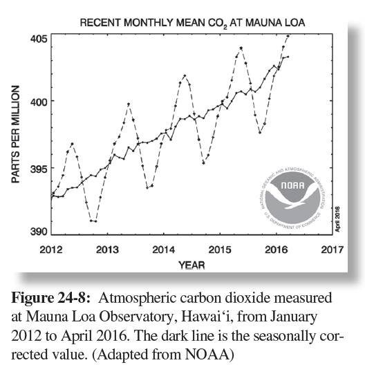
Which city exhibits the greatest precipitation variability? Why?
The question is based on Figure 24-8, charts showing annual precipitation in Tucson, Arizona, and Bozeman, Montana, from 1905 to 2015.
What will be an ideal response?
Which of the following situations is most likely to develop smog?
A. A small city on a mountain top with a cold climate. B. A small city in a valley with a cold climate. C. A large city in a valley with a hot climate. D. A large city in a valley with a cold climate.
In the Late Mesozoic, a body of water extended from the Gulf of Mexico to the Arctic Ocean and
was called the ___________________ Fill in the blank(s) with the appropriate word(s).