Viewshed analysis can be performed using:
A. a TIN
B. an elevation raster
C. both an elevation raster and a TIN
Answer: C
You might also like to view...
A parcel of air with an initial temperature of 80°F begins to rise in Location B. The LCL of the parcel is 4000 feet. With a red (or labeled) line, carefully draw the temperature decrease of this parcel of air as it rises to 10,000 feet. Be sure to consider the LCL, and the DAR and SAR.
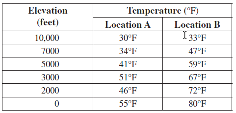
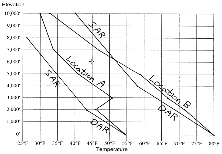
(a) Will this parcel of air begin to rise from the surface on its own? Why?
(b) Does the stability of this parcel change with increased elevation? If so, at what elevation does this change occur?
(c) How would the pattern of stability below 10,000 feet be different if the lifting condensation level was not reached until 9000 feet?
What is refraction, and how does it occur?
What will be an ideal response?
Which of the following is not part of the UN Development Programme’s Human Development Index?
a) GNP per capita b) Life expectancy c) Knowledge access d) Level of inequality
A river's velocity is ________ on the outside of a meander curve compared to the inside.
A. equal B. lower C. higher