Examine the full-page photograph at the beginning of this chapter. The aerial view in eastern Washington shows natural hillslopes and farmland. The yellow areas are growing wheat
The remaining areas are covered in native grasses. Explain how the farming practices visible in the photograph are designed to minimize soil erosion.
What will be an ideal response?
There is no farming in the steep ravines, where disturbance of the soil for planting would enhance erosion. Some of the planting has been done along the contours of the landscape, which slows down potentially erosive water runoff along the surface. Land planted in wheat alternates with strips of land that remain covered in native grasses; this means that there is always some plant cover present year-round to slow down erosion by water and wind.
You might also like to view...
What is the name for the density zone in which temperature changes rapidly with depth?
a. pycnocline b. thermocline c. halocline d. mixed layer e. deep zone
Calcareous oozes are more common in deep water than shallow water.
Answer the following statement true (T) or false (F)
Water penetrating into soil promotes chemical weathering by acting as a weak ________
A) acid B) base C) saline solution D) neutral agent E) catalyst
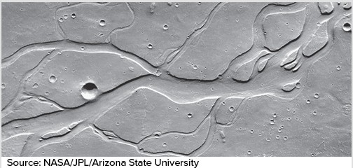
The erosional features shown in this image from Mars are thought to have been formed by
A. tectonics. B. glaciers. C. running water. D. wind.