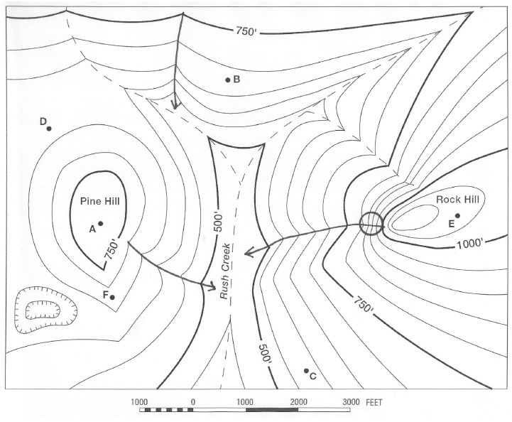
How deep is the depression (from the lip of the depression to its bottom)?
The question is based on this contour line map with elevations shown in feet.
• North is to the top of the map.
• Streams are shown with dashed lines.
• A graphic scale for measuring horizontal distances is shown below the map.
• Estimate elevations between contour lines to the nearest half-contour interval; assume that the top of a
hill is one-half-contour interval higher than the highest contour line shown.

What will be an ideal response?
100 feet
You might also like to view...
Which of these US cities has the least worry about the availability of groundwater due to groundwater overdrafts? Refer to Figure 3.12
A. Bozeman, Montana B. Dallas, Texas C. Tucson, Arizona D. Miami, Florida
Which emits radiation of the highest frequency?
A. The Sun. B. A blue-hot star. C. A red-hot star. D. all the same
Age determinations from radioactive-isotope decay methods are usually performed on a mineral crystal. Assume that a rounded grain of feldspar is plucked from a sandstone, analyzed, and determined to be 200 million years old
What does this tell you about the age of the sandstone? What other methods can be used to determine when the sand in the sandstone was deposited? What will be an ideal response?
Why are houses in hurricane-susceptible areas generally on tall posts?
a. to keep them above the high tide level b. to keep them above the expected storm-surge level c. to allow blowing sand to go under them d. to keep them above the strongest winds e. to provide less wind resistance