What is the name of the adjoining quadrangle to the south?
The question is based on the lower right (southeast) corner of the “Greasewood Spring, Arizona,” quadrangle (Maps T-18 and T-19 shown in color in the back of the Lab Manual).
What will be an ideal response?
Arrowhead Butte
You might also like to view...
What type of "root" did the first vascular land plants have, and what type of environments did they live in?
The following diagram illustrates the Rock Cycle.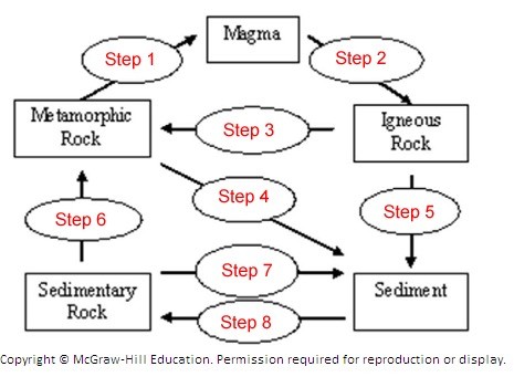 The diagram illustrates the Rock Cycle. Match the item below to step number 6 on the diagram.
A. Cementation and compaction (lithification) B. Heat and pressure C. Weathering, transportation, deposition D. Cooling and solidification E. Melting
Stability is measured using a sling psychrometer
Indicate whether the statement is true or false
When a wave is too steep to support itself, the wave front collapses creating a ________ that advances up the shoreline
A) trough B) break C) fetch D) swell