On all three graphic scales for the map, “0” is not at the far left. Explain the reason for this.
The question is based on the lower right (southeast) corner of the “Greasewood Spring, Arizona,” quadrangle (Maps T-18 and T-19 shown in color in the back of the Lab Manual).
What will be an ideal response?
To make it easier to determine fractions of miles, etc.
You might also like to view...
During the early part of the Mesozoic Era, numerous rift basins formed in the Appalachians
related to the separation of North America and Africa. Indicate whether the statement is true or false.
Potential vorticity
A) does not depend upon planetary vorticity. B) does not depend upon relative vorticity. C) need not obey Conservation of Angular Momentum. D) is unrelated to the Coriolis force. E) none of the above
Coastal Florida is unlikely to be affected by sea level rise, as there are minimal low-lying areas.
Answer the following statement true (T) or false (F)
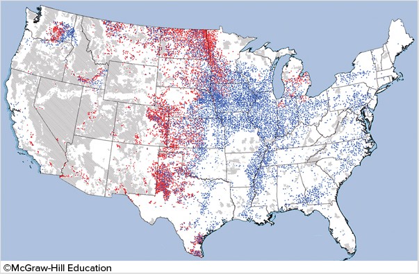
The red areas in the map below are places where
A. soil erosion due to wind is a major problem. B. soil is being formed faster than it is being eroded away. C. salinization is leaving the soil ineffective for agriculture. D. soil erosion due to water is a major problem.