What is the elevation of this highest location?
The question is based on this contour line map with elevations shown in feet.
• North is to the top of the map.
• Streams are shown with dashed lines.
• A graphic scale for measuring horizontal distances is shown below the map.
• Estimate elevations between contour lines to the nearest half-contour interval; assume that the top of a
hill is one-half-contour interval higher than the highest contour line shown.
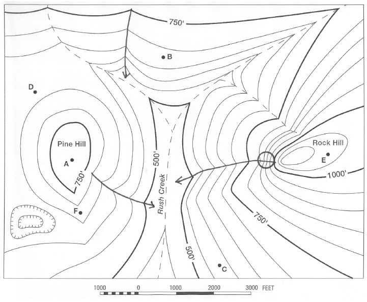
What will be an ideal response?
1125 feet
You might also like to view...
What did the USGS discover when they studied the Slumgullion feature?
A) There were different parts with different ages. B) Movement formed folds, faults, fissures, and zones of shearing. C) Some parts of the material moved faster than other parts. D) All of these are correct.
True or False: All clay-mineral grains in a clastic sedimentary rock are clay size
Indicate whether this statement is true or false.
When a large number of tornadoes develop in association with a particular weather system (typically six tornadoes or more), it is referred to as a ____
a. megacyclone b. mesocyclone c. tornado family d. tornado epidemic e. tornado outbreak
All of the following impact sea surface temperature (SST) EXCEPT
A. currents moving cold water away from poles on the western sides of oceans. B. upwelling that brings cold, deep water to the surface influencing SST. C. increasing SST with decreasing latitude in both hemispheres. D. currents moving warm water away from equator on the western sides of oceans.