What is the current regulatory standard for gasoline mileage of automobiles in the United States?
A) 35 miles per gallon
B) 22 miles per gallon
C) 30.5 miles per gallon
D) 27.5 miles per gallon
E) 33 miles per gallon
Answer: D
You might also like to view...
What is the basic rule of toxicity?
What will be an ideal response?
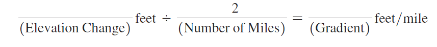
Using Map T-2, the “Umnak, Alaska,” topographic map (scale 1:250,000; contour interval 200 feet), calculate the gradient of Mount Vsevidof (53°07'35"N, 168°41'16"W) along line CD, from the 1000' contour (near Point C) toward the summit. On the edge of a piece of paper measure out a distance of 2 miles using the graphic map scale, and then determine the elevation change over that distance.
In this problem, you will compute the gradients of Mauna Loa in Hawai‘i, Mount Vsevidof in Alaska, and SP Mountain in Arizona. (You may also determine the elevation changes and distances needed to calculate these gradients by using Google Earth™.) The recommended starting point and distance to measure are given for all three volcanoes.
Kulturnost in Russian means "uncivilized behavior," such as that displayed by Pussy Riot in Moscow's Christ the Savior Cathedral
Indicate whether the statement is true or false
The yellow-red stains that occur on some rock surfaces are the result of ________ which is a form of ________ weathering
A) hydration; chemical B) hydration; physical C) oxidation; chemical D) oxidation; physical E) solution; chemical