The acquisition of data about Earth's surface from a satellite orbiting the planet or from another long-distance method is
A) GIS.
B) GPS.
C) remote sensing.
D) aerial photography.
E) USGS.
Answer: C
Environmental & Atmospheric Sciences
You might also like to view...
Which of the following sites would have the most dangerous volcanoes? A is on an island arc, B is in the Andes, C is near Hawaii, D is along a midocean ridge.
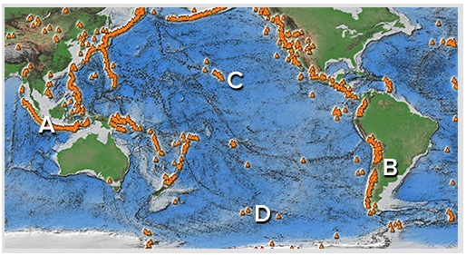
A) A and B
B) B and C
C) C and D
D) A and C
E) B and D
Environmental & Atmospheric Sciences
What is permafrost, and what problems are associated with construction in a permafrost environment? What will be an ideal response?
Environmental & Atmospheric Sciences
The zone of ____________________ is the portion of a glacier where additions exceed losses
Fill in the blank(s) with correct word
Environmental & Atmospheric Sciences
The arrangement of a phenomenon across Earth's surface is
A) dispersal. B) spatial analysis. C) spatial association. D) distribution. E) regional dissociation.
Environmental & Atmospheric Sciences