Which Library of Alexandria librarian is responsible for the development of the longitude and latitude
system?
a. Hipparchus
b. Claudius Ptolemy
c. Hypatia
d. Eratosthenes
ANS: D
The first system of longitude and latitude was invented by Eratosthenes. He placed the lines through
key landmarks so it was different than the system we know today. Information can be found in the
section Understanding the Ocean Began with Voyaging for Trade and Exploration.
You might also like to view...
The polar bear is a(n)____________________ species to cold regions.
Fill in the blank(s) with the appropriate word(s).
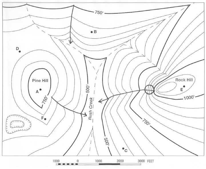
What is the elevation of Point A?
The question is based on this contour line map with elevations shown in feet.
• North is to the top of the map.
• Streams are shown with dashed lines.
• A graphic scale for measuring horizontal distances is shown below the map.
• Estimate elevations between contour lines to the nearest half-contour interval; assume that the top of a
hill is one-half-contour interval higher than the highest contour line shown.

What will be an ideal response?
In which part of the area in the Investigation would you most likely find uncontaminated groundwater?
A) North B) East C) South D) West
All of the following must be assessed when making a land use plan EXCEPT:
A. the purchase of land suitable for development. B. the geologic nature of the area. C. transportation issues. D. the cost of implementing the plan.