The potential evapotranspiration of a location is controlled primarily by:
a. total annual precipitation.
b. temperature.
c. vegetative cover.
d. precipitation intensity.
B
You might also like to view...
Do all of the terraces shown on your topographic profile extend, without interruption, to the southeast and northwest along this side of the island?
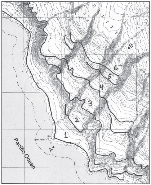
The following questions are based on Figure 49-8, a portion of the “San Clemente Island Central, California” quadrangle shown on the following page (scale 1:24,000; contour interval 25 feet; index contours drawn every fourth line; to view this map in color, go to the Lab Manual website or scan the QR code for this exercise), and the stereogram of San Clemente Island (Figure 49-7). The map and stereogram show a series of marine terraces on San Clemente Island in southern California (32°51"08"N, 118°29'58"W). The terraces have been incised by streams in several places.

Figure 49-8: USGS “San Clemente Island Central, California” quadrangle (scale 1:24,000; contour interval 25 feet; note that the index contours on this map have been drawn every fourth line;cN)
Which is NOT likely true about the large number of Syrian migrants arriving in Europe?
A) This movement is evidence of political push factor. B) This movement is evidence of an economic pull factor. C) This movement is evidence of a brain drain. D) This movement is evidence of counter-urbanization. E) This movement is challenged by the intervening obstacle of European hostility to migrants.
What is the difference between a pyroclastic flow and a pyroclastic surge (aka surges)?
What will be an ideal response?
Which types of purchases have decline as a share of spending in the U.S.?
A) home purchases B) food and clothing C) medical care D) holiday shopping E) none of the above